Roland's First Deathride
Tour of the California Alps
July 14th, 2001
|
Roland's First Deathride Tour of the California Alps July 14th, 2001
|
|
Introduction
|
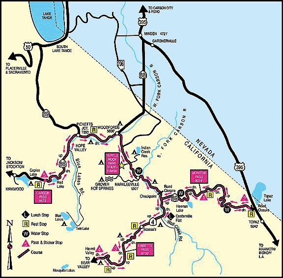
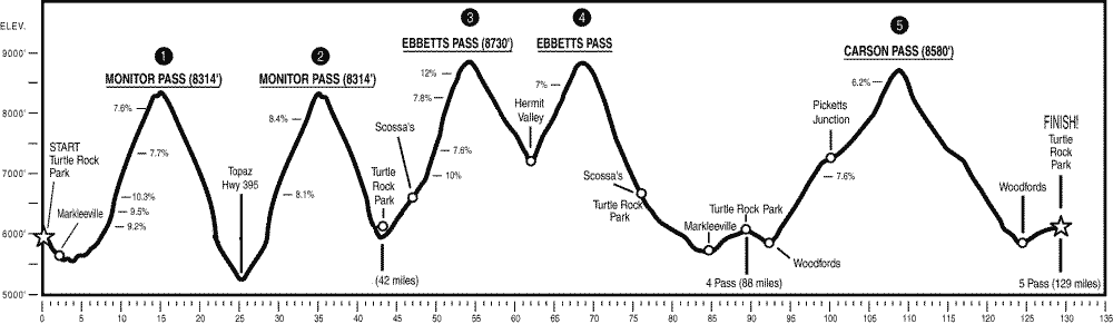
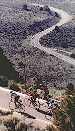
The Deathride, now in its 20th year is one of the most challenging cycling endurance events in California. In includes five mountain passes, Monitor twice, Ebbetts twice, and Carson, in that order. Riders who complete all five passes will have ridden 129 miles, and climbed 16,000ft. For 2001 the event was held Saturday July 14th, the weather was fantastic, starting a little cold but it never became too hot to ride, probably reaching around 80F at the most. |
|
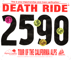
Preparation I only started riding four months before the event, my longest ride was a century, which I had only done twice, with a maximum climb of 7000ft. Although I didn't see it as a big deal everyone I spoke to asked me if I had done any training in high altitudes, as the entire event is held between 5500ft and 8700ft. My answer, of course, no, the highest I had climbed to was 1500ft! Fortunately I don't really think the altitude actually made any substantial difference, other than psychological. However, at least the bike was ready, I had a triple with a 30T (standard) and a rear 12-27 cassette - the largest standard setup you can get in Ultegra. Registration The day started in Carson City, with a wake up call at 4am. By about 4:30am we were on the road to Turtle Rock Park just north of Markleeville. After getting my registration "Deathride water bottle" and registration numbers for my helmet, shirt, and bike I was ready to go. Interestingly carrying their water bottle is mandatory even if you don't have a water bottle cage and use a camel back. Fortunately this snippet of info was posted to their website and I had bought an extra water bottle cage just to carry around their bottle empty for the ride!.
|
 |
Pass 1 - Climb up the the West side of Monitor
 |
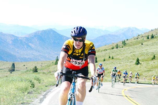
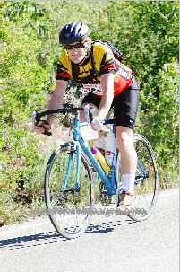
I started at 6:05am from Turtle Rock Park, as rider 2590, of only 2700, I hadn't realized how lucky I had been in getting a place until I saw my number. I was only one of the few riders wearing only a short sleeved shirt and shorts. The downhill from Turtle Rock to Markleeville certainly made an easy start to the ride, but also a freezing cold one. My whole bike was shaking from me shivering so much as I sped down to the intersection of the 89 and the 4. This was where they checked that you had your registration numbers and water bottle, I think it might have been a little more appropriate to have checked 8 miles earlier at Turtle Rock, but anyway I was fine. The 10 mile climb up the 89 to Monitor pass wasn't as bad as I expected, the stretches of 10% grade didn't seem any worse than what I had done at home where the steepest is grade is only 8%. I was certainly seeing how my low gearing was helping, there were parts where I was doing 70-80rpm and others, especially those with only a double front ring were probably doing something around 50rpm and certainly hurting.
|
Pass 2 - Descent to Topaz at the 89/395, and the return up the East side of Monitor
 |
The first big, long, downhill, what a ride; 9.5 miles of downhill at grades up to 7%, to conserve energy, and because it was rather pointless cycling downhill I tucked into an aerodynamic position and coasted at speeds up to 48pmh. After almost 10 miles of downhill with my head straining up from the tucked position my back was hurting already - and only after about 30 miles. The return, although a lot slower was certainly warmer, the decent had again been freezing cold and climbing up hill for almost 10 miles with no reprieve in climbing until the top was definitely a challenge, this was when I started questioning how much further I would be able to go. |
|
Unlike on the decent when I had been paying attention to staying on the road without risking myself or other riders, the climb allowed for time to look at the scenery, the views on this climb are amazing, and undoubtedly some of the best high valley mountain scenery for miles. |
 |
Pass 3 - Decent from Monitor, climb up the East side of Ebbetts
 |
Again the decent from Monitor, this time down the side I originally climbed, was awesome. The road was beautifully smooth without a bump in sight, all the corners were approachable at maximum coasting velocity and the road was wide enough to overtake other riders while they were over taking yet slower riders too. My maximum speed, and the best for the day, was 51.7mph - coasting! The third pass, and the one I was worried about. The climb from the 89 and 4 to the top of Ebbetts was around 13 miles including sections where the grade was 8, 10, and even 12%. It starts out with a reasonably easy low grade climb for the first few miles along the side of the river, but for the last 8 miles was truly the essence of the Deathride, I was shattered and ready to go home.
|
|
Pass 4 - Decent from Ebbetts to Hermit Valley, and the climb up the West side of Ebbetts At the top of Ebbetts I asked other riders how far to Hermit Valley, to determine whether I'd be able to make it back up, less than 6 miles and 1400ft. I figured it shouldn't be too hard, especially as the maximum grade was 7%. The decent from Ebbetts to Hermit Valley was unlike Monitor's descents, the corners were slightly sharper, the road narrower and the surface bumpy and in patches potholed. I probably didn't do much over 40mph at any point. Oh boy, the return climb although only 7% and for less than 6 miles, was the hardest yet, and my speed dropped down to the 3mph range for quite a while, it was at this point I decided this was going to be my last pass for the day. Rather than stopping at the top of Ebbetts again I decided to "fly on by". Back to Turtle Rock I left the top of Ebbetts, at around 1:30pm, with only 68 miles completed, but at least most of the climb was done. The ride to lunch was an enjoyable, but dangerous, 12 miles of switch back downhill with grades up to 12%. The danger became immediately obvious when I saw one cyclist receiving first aid from one of the medi-aid motorcyclists, probably with an ambulance on the way too. He had burnt rubber onto the road for 40-50ft leading in a straight line across a corner into the mountain face. He was fortunate he hadn't made the same mistake on the next corner which would have resulted in an airborne cliff flight off the side of the mountain. Lunch was at the 80 mile marker and following my sandwich and salty vegetable soup, that would probably normally have tasted awful, but tasted great for us salt deprived cyclists, I rode another 7 miles downhill to Markleeville. Riding through Markleeville was great there was a large crowd ringing a Swiss cow bell and cheering us on, also I had the fortune to have found a pace-line being led by a tandem duo who were racing us through town. After having ridden 19 fast miles and feeling great I was, again, thinking about doing the 5th pass. But the three miles from Markleeville to Turtle Rock, much of it in first gear, climbing only what should have been an easy 400ft made me think I must be insane to want to do another 3300ft to get to Carson, the 5th Pass. I had done 90 miles and climbed 12,700ft, but Carson would have to wait until next year and a bit more training.
|
© Roland Wooster, 2007. All rights reserved.